Tuesday, July 13, 2010
We've moved!
Welcome to digashkelon.com
See you there!
(I'll be making up for the lack of blog posts over the past few weeks in the coming days. Good things have been happening.)
Wednesday, June 30, 2010
A Race to Pottery Washing
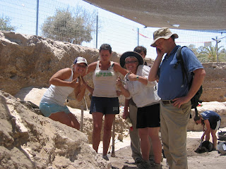
Quick, can I write an entry before pottery washing and still have time to get some Ice Coffee? Let's see.
Today, in our latest edition of "Getting to Know You" I'd like to introduce you to Dr. Daniel Master, Co-Director Ashkelon Excavations and Associate Professor of Achaeology at Wheaton College. Here goes.
Dr. Master doesn't remember what he wanted to be when he was little but he does remember that he was notorious for telling his cousins where to dig. Today, Dr. Master is still telling everyone where to dig. In fact, that is an important part of his job as co-director. Dr. Master's job is to plan the season's work, find people who want to do the same work and then make it happen and do whatever he can to make sure all the work gets done. His favorite part of the job is working with people he likes. And he has no least favorite part of the job because, he told me, if there was something he didn't like he would change it.
Favorite tool: Trowel
Most interesting find he has excavated: 604 BC destruction of Ascalon
Favorite treat while in Israel: Ben and Jerry's Cherry Garcia Ice Cream Bar covered in Dark Chocolate
BTW, the answer to the question is "no." I wasn't able to post this before pottery washing. At 8:19 it is now just 11 minutes until my bedtime. Until next time, the dirt is ready!
Saturday, June 26, 2010
Getting to Know You
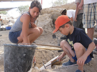
Today's installment of "Getting to Know You" features Robyn, a Ph.D. student in the Classics Department at the University of North Carolina. When I asked Robyn what she wanted to be when she was little she looked a little sheepish and confessed that she always wanted to be an archaeologist. There were obvious signs she told me. First, she was always digging in her back yard when she was a child. And, whenever she played with Barbie dolls she dressed them up as characters in Greek mythology!
Here on the Leon Levy Expedition to Ashkelon Robyn is a Square Supervisor in Grid 47. That means she oversees the day to day excavation of a 10 x 10 meter area within the grid. Robyn's favorite part of the job is the people. She loves meeting new people and teaching them about archaeology. Her least favorite part of the job are the spiders and lack of coffee.
Favorite Tool: WHS trowel
Least Favorite Discovery: A never ending pottery pit she excavated last year
Favorite treat while in Israel: Ice Aroma (basically a mix between a coffee slushie and a coffee milkshake)
Wednesday, June 23, 2010
Tel Tour

Today we had our first Tel Tour. It started in Grid 38 where Josh detailed the latest events. In Square 85 Johnathon and his volunteers have waded through Byzantine and Roman period drains on their way to the Persian period and, happily, what appears to be the first well preserved 8th century BCE floor ever found at Ashkelon. That is certainly a big discovery!
One of the goals of Square 85 is to keep moving towards the level of the gray sandbags you can see in this picture and the one below. Last year they uncovered a very important building dating to the Iron 1 period which extends into Square 85. Stay tuned for Johnathon's progress throughout the season as he gets closer and closer to uncovering the remainder of this important building.
 Further down in the grid in Dana's square they are dealing with fill layers from the LB 1 period and a house with a courtyard from the LB 2. (LB = Late Bronze Age. The approximate dates for LB 1 are 1550 - 1400 roughly and for LB 2 1400 -1200.)
As mentioned previously, Grid 38 is the longest continually excavated grid on site but much of it is coming to the end of its long winding journey. Dana's may very well complete the excavation of his area this summer after which point Johnathon's square and the quest for the remainder of the Iron 1 building under the sandbags will be the focus of work.
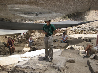 From Grid 38 it was on to Grid 51 and happily I have pictures! Up first, Kate, who you met in our first "Getting to Know You" segment. Here she is explaining her very interesting grid which is newly expanded this season. With the new expansion Kate and her team of supervisors find themselves dealing with a wide range of time periods. They have everything from Islamic and Crusader through the Persian period. All in all some very interesting stratigraphy.
I have a few more details and, I hope, perhaps even a description of the grid from Kate herself who tells me she also has some great pictures to share.

They are very hard to see but if you look at the ground to the right of the volunteer with the red backpack can see some ceramic tiles which come from a Byzantine period villa.

In this picture Kathleen is standing inside a large drain which proved to be much bigger than expected. They also found some great things while excavating it which I hope to have more information on soon!

Under the shade cloth is where the earliest material in Grid 51 comes from. It is here that they hope to come down on the first occupation levels after the 604 BCE destruction of the city.
I realize this is a bit skimpy but pottery washing is fast approaching and I must head off. I promise to have more than just pictures of Grid 51 soon!
Enjoy the dirt!
Sunday, June 20, 2010
Ashkelon Happenings
 I am most tardy with a blog entry so without further ado here is the answer to the most recent "What? Where? When?"
This is a dog burial that dates to the Persian period, approximately 538 - 322 BCE. Between 1985 and 1992 over 1200 dog finds were recorded during the excavation of Ashkelon. Typically single dogs were found in shallow, unlined pits dug into large fill layers. Sometimes they were found dug into narrow streets. The burials were at many different heights suggesting, perhaps, that the burial of the dogs happened sporadically. There is no evidence that the dogs were either killed or diseased. And there is no evidence, such as skewed limbs or other types of distortions, that the dogs were just thrown into the pits. Rather, the dogs were generally buried on their sides with their tails carefully arranged to curl toward their feet.
What can we say about the dogs? Both male and female dogs were buried. They ranged in age from just a few days to extreme old age. There never was any evidence that one type of dog was selected over others although puppies did make up the largest percentage of burials. What about the breed? One of no particular ancestry. Parallels for this outside of Ashkelon are few and far between. If you want to learn more you can read the work of Dr. Brian Hesse and Dr. Paula Wapnish who have studied and written about Ashkelon's dog burials.
We will have another "Getting to Know You" this week. Stay tuned. I also hope to have a guest write a paragraph or two about Grid 51. We will have photos too... Fingers crossed. I know they have been dealing with a big drain which means that things have undoubtedly been interesting of late.
On the recording front. Another way we record information is to take photos of objects, architecture and, of course, stratigraphic relationships amongst other things. So here, for instance Ryan is cleaning a large piece of stone so that we could photograph it before doing any further work.
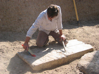
And it is a good thing we decided to take the picture. Last Friday we decided to expand the area of Grid 47, where I work in the theatre, in order to better expose the entirety of the building. So today we had a little extra help and the results couldn't be more impressive -- or messy, truth be told. We'll be cleaning up for a while but that's okay. We'll also have a much better understanding of the building.
So what exactly did we do? Well, stay tuned for pictures from tomorrow's work.
Wednesday is our first tell tour so we should be able to get the scoop on the other grids.
And for today a return to "Who? What? When?"

Until next time, the dirt is ready. Get digging!
Monday, June 14, 2010
Finding Artifacts

Work continues and everyone seems to be making progress. I went on a field trip to Grid 51 today and saw Dr. Kate's newly expanded empire which is quite impressive. One of the most interesting things I saw in her grid was a floor made of mudbrick tiles! There were a number of other interesting things to see in the grid and I hope to post pictures soon so that everyone back home can see all the exciting material.
We have found a number of interesting artifacts in Grid 47 this week from the very large to the very small. For instance, we found a large architectural fragment. We think it might have decorated the of the theatre we are excavating. Ryan is making sure that the marble fragment is labeled so that we know where it came from. Behind him, Mark is entering data into the computer so that everything is recorded properly. We have been finding many pieces of the building as we dig. We have found roof tiles, floor tiles. fresco fragments, mosaic floor fragments and much more. Today we also found a blade or knife made out of iron. The most exciting thing about it was that part of the wooden handle was still preserved which is rather unusual. The knife came from a pit where we found a lot of interesting things including lots of broken pots, a large number of iron nails and lots and lots of bones.
And finally, for the students at Hamilton Elementary. Perry was there when Emily, one of our volunteers, found her fourth oil lamp of the summer! Everyone agrees she is very lucky.
 I want to send out a big thank you to the Hamilton students and families who have been following our work here on the Leon Levy Expedition to Ashkelon. I know that the school year is almost over but you can keep following our work until July 16th when the season ends.
Next entry the answer to our last "What? Where? When?" And hopefully, a new staff member for everyone to meet.
Until then, the dirt is plentiful.
Thursday, June 10, 2010
Who Becomes an Archaeologist?
 Kate has a Ph.D. in archaeology from Harvard where she studied the pottery of the Sea Peoples on the coasts and inland in Anatolia & northern Syria (The Philistines are part of the larger phenomenon of the "Sea Peoples"). When in elementary school, she dreamed of becoming either a conductor or a donut maker. While she still daydreams of pastries, she is now the fearless leader of an entire area of excavation. In this area, she supervises the excavation of material from the Islamic through the Persian periods. During the excavation, Kate spends her mornings teaching the square supervisors how to be better excavators. In the afternoon, she "reads" pottery & teaches her supervisors & volunteers about the pottery that has been dug up during the morning.
Favorite Tool: Pick Axe
Coming soon the answer to the most recent "What? Where? When?" and the next installment of "Getting to Know You."
Wednesday, June 9, 2010
The Professionals
 This week Grids 47 and Grids 38 benefited from the assistance of a team of professionals. First up, Jeffrey, Lucy and Noah. After helping with the cleanup in Grid 47 they went on to Grid 38 where they were able to help in the digging there. The trio did an excellent job shoveling dirt, collecting pottery and bringing smiles to the grid.
Jeffrey, Lucy and Noah weren't the only ones to help in Grid 47 this week. Today the head of the excavation Dr. Master took the opportunity to get his trowel dirty excavating monumental Roman architecture with us.
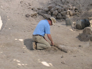 As director of the excavation Dr. Master is very busy and doesn't often have time to dig in the dirt so it was a thrill for us and exciting for him (I'm sure) to spend a few moments in the dirt. Stay tuned for an interview with Dr. Master as the season progresses. We'll soon have an opportunity to ask him about what is new at the ancient city of Ascalon.
As I've mentioned before Grid 47 isn't the only place that we are excavating. Today I wandered on over to Grid 38 to see what they are doing there. In Grid 38 they are excavating a Late Bronze Age house which dates to the 13th century BCE. The house has beaten earth floors and mudbrick walls. When the house went out of use, when the residents left, people used the area for large grain silos that cut through the earlier houses. In one picture you see the ladder that leads to John's square. This square has the latest (or more recent) material in Grid 38. John has Roman and Persian period material as well as material from the Iron Age. He has a long way to go until he catches up with everyone else in the Late Bronze Age. In the other picture you can see another one of Grid 38's Square Supervisors, Madeleine. She is hard at work at her computer. We use laptops in the field to record all of our work and discoveries. By putting everything on the computer it makes it easier for other scholars to see our research as they do their own work.


Monday, June 7, 2010
Progress

Grid 38 is clean . Grid 51 is getting there and in Grid 47 we are definitely making progress. If you remember, in Grid 47 we are excavating what we believe to be a Roman period theatre. Partially exposed by the excavations of John Garstang in the 1920s we have expanded the excavation area and are hoping to expose the full extent of the theatre. We also need to confirm it is a theatre and not some other type of structure using apsidal or curved walls. To do that we are looking for the stage of the theatre. In a Roman theatre there is are very specific words for the various parts of the stage. First, the front wall of the stage is called the proscaenium. The stage itself is called the pulpitum. And the back wall of the stage, through which there would be three entrances leading onto the stage, is called the scaenae frons. These then are the architectural features we are looking for that would help us to identify the structure as a theatre. Happily, today we found a wall, at least two meters wide, that may be either the proscaenium or the scaenae frons. We'll keep you posted our progress. In the meantime, here are some pictures after our first two days of cleaning in Grid 47. We'll take a look at some of the other grids too and let you know what is going on there.

Saturday, June 5, 2010
The Night Before Digging
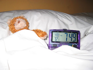
What's up Hamilton Elementary School and the Wider World? Shhhh, Perry (Hamilton's world traveling bear) is in bed. He has to get up very early in the morning to go to work. Tomorrow is the first day of digging. Here are some "before" pictures of Grid 47 where we are uncovering a Roman period theatre. We'll keep posting our progress so make sure you check back!


More about what we are doing in Grid 47 will be forthcoming this week. In addition, we'll be adding a new feature to the blog. It's called "Getting to Know You" and every few days we will introduce and interview a member of the staff. (And if we are really on the ball this new feature will include video footage!)
Until next time, get to bed! The dig day starts early.
Wednesday, June 2, 2010
Just a quick hello
 So, "What? Where? When?" or as I suggested last time, "Who? What? Where."
 The answer is that the image (which I can't post right now since my computer is being a little complicated) is a fresco uncovered in what Professor Stager, co-director of the excavation, identifies as the Church of St. Mary of the Green which is located near Ascalon's Jerusalem Gate. The church, built in the 5th century, was originally laid out as a basilica divided into three aisles by two rows of columns which supported a gallery and a pitched roof. Tradition holds that the church continued to function as such throughout much of the Islamic period before being converted into a mosque by the Fatimids (late 9th - mid 12th century). When the Crusaders conquered Ascalon in 1153 CE the building was restored to a church with some changes in its plan. It was also during the Crusader period that frescoes, part of which you see here, were added to the central apse and two side niches of the church. In the central apse the frescoes are of four saints/bishops reading Greek scrolls, each scroll containing excerpts from the homilies of St. John Chrysostom, who was bishop of Constantinople from 398-407 CE.
Here's the next one. Any ideas?
Sunday, May 30, 2010
A Day in the Life of an Archaeologist
Wake up is at 4:30 AM unless like me you are crazy enough that you manage to wake up at 4:00 without the help of an alarm. (Like I said, crazy!). We wake up that early in order to finish a full eight hour work day before it gets too hot but you don't really think about that when you wake up and it is pitch black outside. You mostly think about how you must be crazy.
Once we manage to pull ourselves together we wander downstairs for First Breakfast (like Hobbits we have a few extra meals built into the day) which usually consists of tea or coffee, bread and jam and what we affectionately call "bug juice" which is sorta but not really like Tang. 5:00 sharp the bus pulls up to take us to the dig site. It is still dark and the ride never takes as long as we would like it to.
By 5:10 we are at the Pottery Compound where we one and all race to grab our tools. We do this by the light of the florescent moon which pierces the still dark morning. Honestly, it is still dark! Then, tools in hand we strike off in the direction we believe will lead us to our designated excavation areas. (We haven't lost anyone yet and, fingers crossed, we won't this year.)
By 5:30 we are usually hard at work even though we can't really see anything. We work using a range of tools from dental picks and tiny paint brushes on up to full size pick axes and shovels (although they have a more fancy name). We dump all the dirt we dig up into buckets called gufas and then haul it away.
We break for Second Breakfast at 9:00 which is both a good thing and a bad thing. It is good because we get a break after a morning of
manual labor and because the meal is pretty good even though we sit in the dirt to eat it (unless you are lucky enough to track down a nice patch of grass). And breakfast is pretty good; all you can eat (at least until it runs out) eggs, bread, olives, cheese, tomatoes, cucumbers, yogurt and more. The only real problem is that you have to go back to work and it always seems much, much hotter after the break.
And then we go back to work until our next opportunity for food or sleep, whichever you need more. Fruit Break happens at 11:15 or so and it only manages to be a Fruit Break if you saved some fruit from breakfast. From that point, however, the morning is almost over and even
though it is so hot your eyeballs are sweating the last bit of the day doesn't seem too bad. 12:50 we pack up our tools. 1:00 we board the buses and go back to the hotel. Once there we get cleaned up and go down to lunch.
After lunch we have free time until 4:00 when we get back on the bus to go back to the Pottery Compound (basically our office at the site) where we work on processing and analyzing the objects we found earlier in the day. We do that for a couple of hours before getting back on the bus to return to the hotel where we then attend evening lectures on any number of subjects from numismatics (the study of coins) to my favorite, Ashkelon in the Islamic period. And then, only then do we go to dinner (usually around 7:15) after which it is again free time. Which in my case lasts until about 8:30 when I go to bed.
So what makes us do it? Well, next time I'll write a bit about what we do when we are working.
Also, the answer to the latest "Who? What? When?"
Hey staff and volunteers! We are inching our way ever closer to the start of the season. Room and grid assignments are done, the hotel is
full (at least on the weekends) and the grids are dirty! See everyone on Saturday.
Wednesday, May 26, 2010
The Basilica
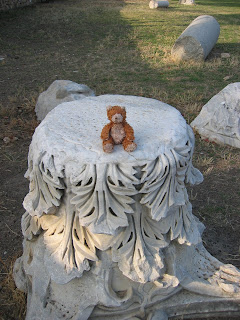 It was a busy day of work today as we started preparing two areas for excavation. Perry, Hamilton Elementary School's traveling bear, visited one of those areas. This is an area in the central part of the site where many of the city's important public buildings were located. It is here that a man named John Garstang first identified one of ancient Ashkelon's basilicas. Today the Leon Levy Expedition to Ashkelon continues to work in the same area so that we can better understand it. We are currently in the process of expanding the area in which we want to work and getting it prepared which means we have to clean the dirt. That's right, clean the dirt. What that means is that we sweep it so that we can see everything in it and believe me there is a lot. When we can see different colors in the dirt we can see things such as pits, floors and sometimes even walls.
This was Grid 47 before work commenced today. Wait until you see it after!
Today work also began in Grid 51 which is being expanded and prepared for excavation. After a week of cleaning both it and Grid 47 should be ready to go.
Monday, May 24, 2010
In Ashkelon
Accompanying my son and I to Ashkelon this summer is Perry, Hamilton's traveling bear. He will be making appearances throughout the summer so keep an eye out for him.
In the meantime, while we begin to prepare for the summer season we are simultaneously working on a number of projects. Here you can see two of Ashkelon's staff members "reading" Iron I pottery. Iron I pottery dates to 1200 - 1000 BCE and the time of the Philistines. When we "read" pottery we look at the shape and decoration of pottery (bowls, pots, lamps, jars, jugs and so on) to determine when it was used. The Iron Age
 pottery in Ashkelon comes from many different places including Cyprus and the
Greek Islands. There are even imports from Syria. The vast majority of the pottery, however, was locally made.
We "read" ceramics from all different periods. While Josh and Laura are working on the Iron Age I am working on Islamic period pottery. At the site of Ascalon, our Islamic period pottery dates from 640 - 1270 CE. During this period we have imports from many different places including North Africa, Egypt, Syria, Iraq, Iran and as far away as China.
The sun is hot, the breeze is mild and it's time to start digging. Stay tuned for more from Perry and for regular updates on our progress this season.
Wednesday, May 12, 2010
Let the Fun Begin -- Soon
The answer to the last "What, Where, When?" is that the picture was taken standing on top of the remains of an unexcavated church located on the South Tel. The view is looking to the southeast towards what may very well have been the intersection of the city's main north-south road with its southernmost east-west road. The stones at the very bottom of the picture are from one of the church's apses.

Friday, March 19, 2010
Summer Plans
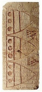
The object shown in the most recent "What, Where, When," is a Fatimid imperial inscription over which a Crusader knight carved his shields. The inscription was found, broken into many pieces, at the bottom of a section of stone talis located just to the west of the main park entrance. The inscription was carved into what excavators suspect was originally a marble tabletop, measuring approximately 1.49 x .63 x .10 m, from the Roman period. The 22 line inscription commemorates the construction of a fortification tower by the local Fatimid governor on the orders of the Grand Vizier in Cairo and even includes the date of the work, 1150 CE.
Monday, February 15, 2010
On the Road to Ashkelon

"What? Where? When?" The short answer is that it is a Roman period bath (dated to the fourth century CE) discovered on the North Tel in the mid-1990s. Excavation of the bath uncovered the furnace, hypocaust tunnels which supported a partially preserved floor and two chambers. The scene depicted in the picture is a group of Romans hanging around in their togas as they relax at the bath. Ok, truth be told it is some volunteers engaged in a re-enactment for the benefit of other volunteers on a Tel tour, a once a week opportunity to visit other excavation areas and learn about what is being discovered. For bonus points, where exactly is the bath located on the North Tel? And can you name one of the two supervisors of this area?
On to other things...
I found this article while procrastinating on some work and include a link to it here as an introduction to Dr. Daniel Master, co-director of the Leon Levy Expedition to Ashkelon.

Friday, February 5, 2010
Dr. Moshier Part 2
Sunday, January 24, 2010
Core Sampling Project
Blog Entry: A big pile of sand (posted July 1, 2009)
All of my T-shirts have brown stains on the part over my belly. The hotel laundry just can't wash out the silt and clay that we are drilling out of Tell Ashkelon. I think the size of the stain is proportional to the size of the belly, a theory confirmed by a quick look at individuals in the pottery compound. I think I’ll have salad tonight for dinner.
The dirt doesn't seem to show as much on my pants, as they are very pale brown to begin with, a shade close to 10YR7/4 on the Munsell scale of soil colors. My typically pale “white” skin color is changed, too, either due to the sun or the absorption of Holy Land clay into my pores. Sunscreen only serves to give the clay something to stick to. Even after rigorous scrubbing in the shower, mud still smears the towel.
On Monday we started a second round of drilling. Archaeology students Ben and David assisted me again. Our driller Efni showed up at the park with his rig at 7 AM. We had been there since 5 AM. Efni packs up and leaves at 3PM and there is no time for lunch before he leaves. Our strategy Monday morning was to push up close to some of the excavation sites. The archaeologists know that the Middle Bronze settlement is built on a cover of yellow sand that extends beyond the (safe) level of excavation. Is the sand part of a dune that covers older cultures? We really wanted to punch through that sand to find out.
The drill is called a bucket auger that looks like a medium-size garbage can with jaws. The rig is mounted on a large tractor that is part forklift and part bulldozer. The drill string rotates and lengthens like a radio antenna, as the bucket churns down through the sediment. It is strong enough to grind through soft rock like the local sandstone, but the scraping sounds like fingernails on a blackboard and louder than a dinosaur in Jurassic Park. When the bucket is full with about 30 to 40 cm of sediment, the drill string is retracted and the bucket returns to the surface. The driller mechanically shakes the sediment out of the bucket, which falls on the ground for examination and sampling.
If everything goes well we can reach a total depth of 11 meters below the surface. Things did not go well Monday morning. At about five meters depth we encountered the yellow sand, but the sand was dry and started caving into the hole. We typically have to pour one or two standard buckets of water down the hole every time the auger goes down in dry sand. The water gives the sand cohesion and conditions the side of the hole to prevent caving. The idea of pouring fresh water down a dry hole seems ironic and perverse. It just did not work and we never got deeper than six meters. We moved the rig about 4 m to the side and tried again with the same results. If there is if there is older archaeological material beneath the sand, we will have to find a better method of drilling to find it. Next, we moved to another location near an excavation site. Same thing. Dry caving sand. Excavation Director Daniel Master stopped by to hear my complaints and told me, “Tell Ashkelon does not easily give up its secrets.”
The last three probes on Monday were more successful. We drilled in the main parking lot located between the north and south tells. The lot was probed in the 1980s but the reports from that survey are difficult to interpret because the descriptions are ambiguous and the depths don’t seem correct. We have good data now and that is the important thing. Even if I offer a lousy interpretation, I want our descriptions of the material and stratigraphy to be useful to future scholars working here.
On Tuesday we started by drilling very close to the beach cliff next to the south rampart built by Crusaders. The goal is to trace deposits evident on the beach cliff landward. Drilling was painfully slow through the sand. David and Ben carried gallons and gallons of water (uphill) from a park faucet some 50 m away from the drill sites. At about 9 AM the cable on the drill rig snapped. Efni called someone to come with a new cable. We were down for about 30 minutes. I fell asleep in the shade sitting up with my legs crossed on the ground. It was hot, but we had a constant breeze from the sea.
The next probe turned out to be our last of the season. It took nearly four hours to drill 10.4 m. We needed lots of water to get through the sand. David and Ben got quite a workout carrying jerry cans of water from an irrigation tap David found about 75 m from the drill site. I wanted to find a place where we would drill to bedrock. We have all assumed that hard sandstone, called kurkar, underlies the tell because it is exposed to elevations of up to 18 m above sea level. But, we have never encountered hard sandstone in our course landward under the tell. We do encounter lots of sand (remember the dry yellow sand from Monday?). We should have reached hard rock in our first probe near the south rampart beach cliff, but we did not. So for this probe we moved the rig to the north tell and set up near the cliff face (about as close as we could safely put it). We should have reached hard rock there, but again we did not! So it appears that the hard rock only occurs along the beach cliff. Hypothetically, the ancient sand dunes that formed the original topography of the tell were only cemented in this narrow zone against the sea. Seawater contains the dissolved calcium and carbonate that probably cemented the rock. We find no other obvious source of rock for the crusader ramparts and structures than the area of the beach cliff and a small quarry close to the cliff on the north tell. It seems then, when we encounter yellow sand anywhere under the tell, we are at, or near, the level of the original topography of the tell. Ashkelon appears to be built on a pile of sand. Our drilling efforts have provided the data to reconstruct the original topography of the site before human habitation and modification of the land.

We did not always encounter what we expected (that would be too easy). But perhaps Tell Ashkelon is beginning to reveal some of its geological secrets after all.
Read more from Dr. Moshier and his team next time to learn more about how geology is contributing to the archaeological exploration of ancient Ashkelon.
Archaeology, It's Not Just For Archaeologists Anymore

"What, where, when?"
First things first, the answer to last month's "What, where, when?" is that the photo shows a Roman period road discovered during the 1992 season. The road and its associated drains were excavated in Grid 2 on the North Tell just outside the ancient city walls. Though exposed the street was never fully excavated and today it is buried under the parking lot just outside the Canaanite Gate
Technology, or How We Get Things Done
The privilege of old age is that I can reminisce with little rhyme or reason about the things that manage to stick out in my memory. So, here are some random thoughts that have managed to linger in the deep recesses of my mind.
Unsurprisingly, over the 20 plus years since I first went to Ashkelon there has been a great deal of change particularly in how we do things. Maybe not going from a horse and carriage to a car level of change but certainly revolutions in both technology and methodology that have changed how we investigate the ancient city. Yep, how we investigate the site and how we stay connected with the wider world as we live in the whirlwind that is an excavation season.
For instance, back in the day technology at Ashkelon meant those ultra thin, light weight air mail letters you could send home. You know the ones you fold and seal shut no envelope needed. That was pretty fancy stuff.
Archaeologically speaking pencil and paper were the recording tools of trade and the only computer on site was a cranky old thing in the dig office that all the supervisors shared along with the team of dig registrars. At the end of the season when square reports were due BEFORE the final dig party that machine saw a great deal of love and attention.
By the early 90s we advanced sufficiently to have access to e-mail. By “access” I mean that the e-mail was sent to the aforementioned cranky old beast in the dig office where it was then downloaded and printed (one screenshot at a time) before being distributed to the designated recipients. And by “we” I mean members of the professional staff. In other words, while a limited few of us had e-mail we had little privacy and certainly few secrets. Did I mention that e-mail came via a 300 baud modem? For those of you not old enough to know what that is, imagine a bunch of hungry alley-cats fighting over food and then toss in a chorus of crying babies. Finally, drop a spoon into the kitchen disposal, listen to all those glorious sounds together and you’re just about there.
Today things are quite a bit different. Pencils and paper are a thing of the past. We actually use laptops in the field to do all our data entry. Anyone with a laptop and I do mean anyone has access to e-mail and the joys of the internet. Need to check the score of the Cubs’s game? You can do that -- just about anywhere you want. Need to update your Facebook page? Doable.
The pervasiveness of computers, both in and out of the field, isn’t the only thing that is different about Ashkelon and the way we do things. In the past few seasons we have started some new projects, one doing ground penetrating radar and another doing core sampling, to help us investigate more areas of the site. These projects use methods that are less invasive than traditional excavation and not only do they help to further our research goals but also they help to shape those goals.
The core sampling project is headed by the team’s geologist Dr. Stephen Moshier who is an Associate Professor of Geology at Wheaton College, Illinois.
Born and raised in upstate New York Dr. Moshier studied geology at Virginia Tech (BS, 1977), SUNY Binghamton (MA, 1980) and Louisiana State University (PhD, 1987). His previous professional experience included working in the petroleum industry and a faculty position at the University of Kentucky. His teaching responsibilities cover areas of general geology, earth history, sedimentary petrology, and geoarchaeology. Prior to 2000, professional interests were focused on ancient limestones and petroleum geology. From 2000 to 2007, Moshier served as team geologist for the Tell el-Borg excavation in the NW Sinai, Egypt and in 2008 he joined the Harvard University-Leon Levy Expedition to Askhelon, Israel.
Dr. Moshier has generously allowed me to reprint some of his blog entries about his work during the 2009 season. The first of two entries will follow after this one.
Now, for the latest “What, where, when?” Any ideas?
One final note, we have a new website for you to check out. The address is digashkelon.com. Visit it to see our flyer about the upcoming season. The site is still under development but check back in the future to see more about Ashkelon and what we do. We also have a new e-mail address, info@digashkelon.com.
Thanks and see you next time!


